To follow 66 in Williams, you can do a loop through this small town, west along the railway and east up Main Street. It was not by-passed by I40 until 1984, which may explain why it is still busy, and apparently thriving, with a number of small motels as well as chains. This bed and breakfast place has a traditional way of enticing customers. (Took this on LIVE by mistake, so not sure how it will come out. That is such an annoying function.)
Williams is also a railway town, attracting tourists by running a daily service to and from the Grand Canyon in this vintage train.
Much of this section of 66 has disappeared under I40, so the next town accessible is Ashfork, about 20 miles west. Very little remains. You enter Ashfork over Ashfork Hill which gives panoramic views of the Prescott National Forest.
 |
| A Desoto on Desoto's |
At Exit 149 of I40 (meaning 149 miles to the Californian border), 66 takes off north and west through the Prestcott Forest (think cacti, not trees) and over the Sitgreaves pass, down into the Colorado Valley, before rejoining I40 at the border. You are about 100 miles south of the south rim of the Grand Canyon; at a place called Peach Springs, it can be glimpsed from 66, if you squint.
Burma Shave was a brand of shaving cream, famous for its advertising signs posted along highways. Given that they are as distracting as mobile phones, I doubt they would be allowed now. Some replica signs have been posted along the roads, starting at Paulden where you leave I40, towards Seligman, the next little town. Another health warning needed.
Seligman is the home of the Arizona branch of the Historic Route 66 Association, so it is full of authentic, and not-so-authentic, 66 branded buildings. It has an Annual Fun Run - which means bikes, not feet. Say hi! to Betty.
These mannequins suggest that cruisin' 66 is beyond cool. The ones on the street are real.
 |
| I think she has been overcome by the vibe |
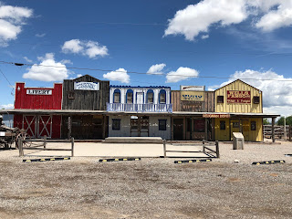


I can't tell if this is original or a mock-up, but it is not unlike other towns seen on the way. The Jail-cart and Jail are authentic.
 |
| Ah. The dangers of phonetic spelling. |
This might be the Grand Canyon in the distance, glimpsed from the hill outside Peach Springs, the centre of the Hualapai Indian Reservation.
 |
| Prescott Forest - open high desert |

 |
| Penstemon jameii? |
These photos were taken between Crozier and Valentine.
 |
| Linanthus species, possibly jonesii |
 |
| Sphaeralcea species (globe mallow) |
 |
| Desert marigold Baileya multiradiata |
 |
| Unidentified as yet |
 |
| Silver-leaved nightshade Solanum elaeagnifolium |
Why is it so difficult to identify these flowers? In case you were wondering. I have apps for wildflowers in all the states through which I have travelled. There are over 3226 species of plant in the Arizona app, some highly localised. First, unless you can recognise the
genus (
rosa, solanum, penstemon etc.) from wild or garden plants at home, you are mostly blind and have to rely on the identification algorithm in the app, based on field marks. If you can recognise the
genus, then you can type that in and it will narrow down the search significantly. You then just have to worry about which
species of the
genus it is. So,
rosa banksiae or
solanum elaeagnifolium ). To do that, you have to rely on field marks - colour, number of petals, arrangement of leaves, habitat and narrow a search in the app. This may give you a few dozen or a handful. You can then scroll through and look at the pictures. However, colour photography distorts flower colour, particularly in the red/blue spectrum. Also, not all the photos in the app clearly show leaf arrangement. I am identifying these through the photos I take, not in the field, or I would still be in Missouri. So, my photos have to show similar characteristics to those in the app. Sometimes they do, sometimes they don't. It is not always obvious which characteristic of a plant distinguishes it from others in the genus.
I bet you wished you hadn't asked.
I love these trains. Here is the Santa Fe railway heading east, pulling up the steep gradient at Crozier
as the road heads down into Crozier Canyon.
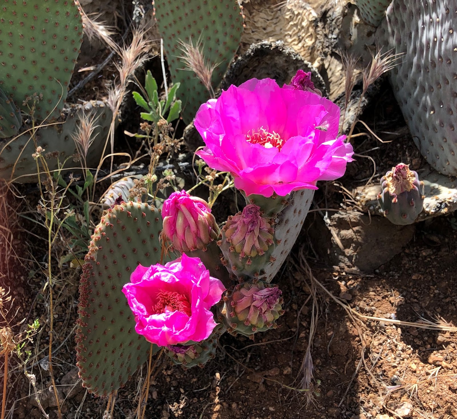
Whereas some plants are just coming into flower, others seem to be already in seed. I was hoping to reach the Mojave desert before the spring flush of annual flowers was over. Not sure I will be lucky. But the cacti are just coming into bloom.
 |
| Prickly pear Opuntia polyacantha. Also comes in yellow. This is where the fruit comes from. it is made into jam here. |
 |
| Typical desert vegetation |
At Valentine, there used to be a thriving trade in sending postcards in February.
There is no reason for a Tiki head to be here at Hackberry, just east of Kingman.
The road towards Kingman runs straight across the open desert. I was lucky to see a male and two female pronghorns on this stretch of land and more new species of plant.
 |
| Mojave Prickly Poppy Argemone corymbosa |
Kingman has a museum in a former electricity generating station, the Powerhouse, which was worth a visit for the Steinbeck references. They have extensive quotes from "The Grapes of Wrath" on the walls around this exhibit of an Okie wagon. I intended to read this as I travelled, driving in the footsteps of the migrants as they headed west. I haven't opened it. It was Steinbeck who coined the phrase "the Mother Road". I think it is worth reminding us what a great writer he was - and a plague on you, Mr Gove, for removing him from the GCSE syllabus. A straight path from there to Brexit.
"66 is the path of a people in flight, refugees from dust and shrinking land, from the thunder of
tractors and shrinking ownership, from the desert's slow northward invasion, from the twisting
winds that howl up out of Texas, from the floods that bring no richness to the land and steal
what little richness is there. From all of these the people are in flight, and they come into 66
from the tributary side roads, from the wagon tracks and the rutted country roads. 66 is the
mother road, the road of flight."
No 66 museum is complete without cars.
 |
| Studebaker Champion |
Just outside Kingman, heading west, the countryside continues wild, open and empty across the Sacramento Wash towards the Black Mountains. There are few cars, which is just as well as a Roadrunner did what they do - ran across the road. Why Warner Bros. and Loony Toons decided to make Roadrunner bright blue is a mystery. They are actually brown, blending into the desert. They are fierce predators of snakes and small mammals. They rarely fly, preferring to run after their prey. Roadrunners and tumbleweed were on my bucket list when we first travelled to California and Nevada years ago, as emblematic of the Wild West. I am still surprised when they do what it says on the tin.
The lack of traffic was also lucky for this little fellow, who was basking in the sunshine. He was quite big - bigger than Emma's Sheldon.
As the road climbs through the Black Country, this sign warns of one of two mammals you might be lucky enough to see. The other is bighorn sheep.

But who thought you might actually see wild donkeys or burros? They were introduced from North Africa in the 17th century and used by prospectors in the 19th, and released into the wild when the ore ran out. In 2016 there was considerable agitation about the numbers of wild donkeys roaming this part of Arizona, and demands for controls. They are federally protected.
The EZ guide warns drivers about the twisting road as it climbs towards Sitgreaves Pass, probably because roads in the US tend to go straight through everything in their path, eliminating pesky bends. For a Brit used to driving on two-lane roads and for anyone who has driven up anything higher than a molehill, this is really not a big deal.
 |
| Smug face |
 |
| Looking towards California from the Pass |
 |
| California and Nevada visible (NV to the right - north) |
The EZ Guide also becomes hysterical about the road down.
 |
| The road down from the Sitgreaves Pass |
As you approach the bottom of the pass, the worse signs of human habitation return. The Americans have no sense of irony. This opposite the next two in this wild place.


Oatman is a small town on the west side of the Black Mountain. It makes the most of its position on Route 66 and as a former gold mining town. it would be much improved by some parking management.
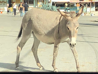 |
| Not all the donkeys are wild. |
At Topock, you leave Arizona and enter California over the Colorado River. There were two suggested side-trips in the EZ Guide, taking you to where the old 66 crossed the Colorado. But it was getting late and I wanted to find somewhere to stay, so I missed those.
About 15 miles further north-west is Needles, a town split in two by I40. Although they have a perfectly good main road, Broadway, running through the whole, locals direct you on to I40 to go one exit between the two halves. There are plenty of signs of 66 throughout.
This is the recently restored El Garces station hotel as it looked when built. This is a mystery photo. I didn't take it and it is not on my Iphone or my camera. I am baffled. I can only assume that I was looking up some info on it and linked it by mistake. See tomorrow's blog for how it looks now.
Decided to have dinner out tonight at the Wagon Wheel, as recommended by the hotel receptionist (she of "take the I40 one exit"). The owners have been running the place since the 1970s and she was right about the food. The old boy in the chair greeted guests. The "ornaments" are insulators from old electricity transmission poles. We have one at home bought from an antique shop somewhere out here a few years ago.

More about Needles tomorrow. By the way, it is named after the surrounding mountains.


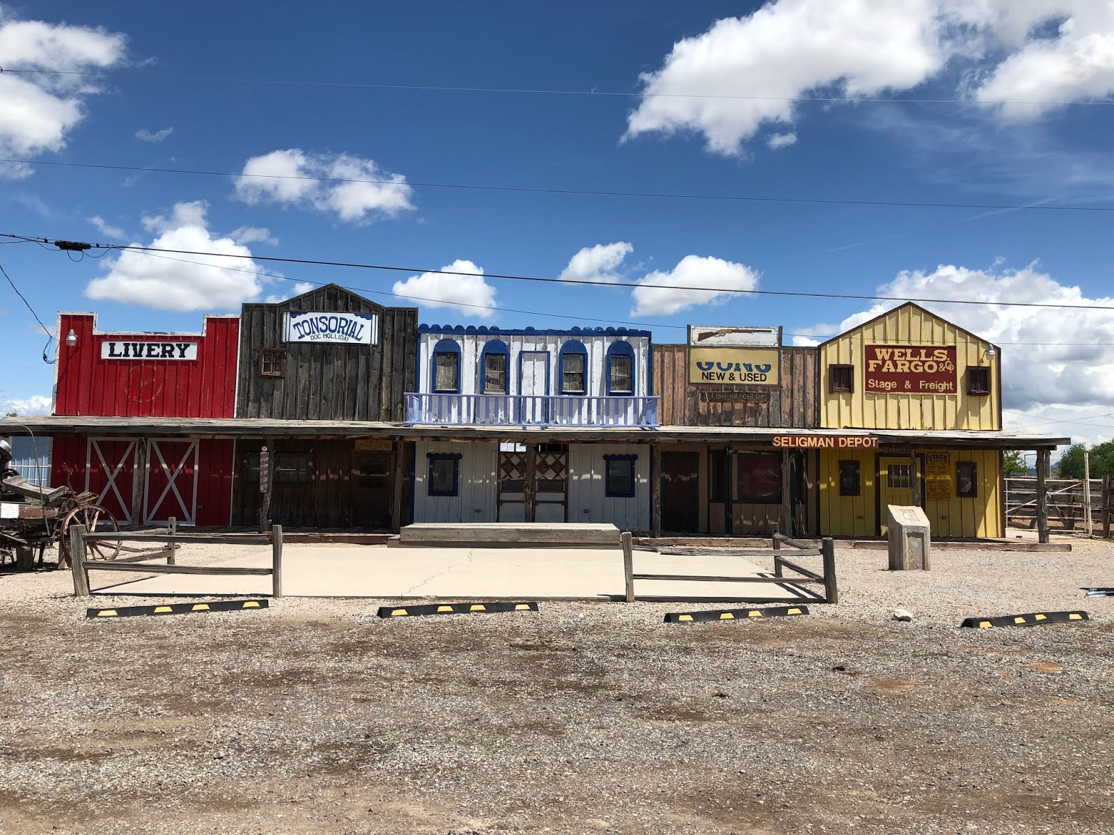

 I can't tell if this is original or a mock-up, but it is not unlike other towns seen on the way. The Jail-cart and Jail are authentic.


 But who thought you might actually see wild donkeys or burros? They were introduced from North Africa in the 17th century and used by prospectors in the 19th, and released into the wild when the ore ran out. In 2016 there was considerable agitation about the numbers of wild donkeys roaming this part of Arizona, and demands for controls. They are federally protected.


No comments:
Post a Comment